How severe was the rainfall during the Crete weather catastrophe?
The intensity of the precipitation recorded during this event reached extreme levels, particularly in the mountainous interior of the island. Data from the National Observatory of Athens and meteo.gr indicates that Anogeia experienced a peak rainfall rate of 92.20 mm/hr, a figure that classifies the event as exceptionally heavy rainfall. This extreme volume of water in a short timeframe overwhelmed natural drainage systems and local infrastructure.
Other areas also recorded significant precipitation levels that contributed to the widespread flooding. For instance, Samaria saw intensities of 45.80 mm/hr, while Rustiko in Rethymno recorded 43.40 mm/hr. Plakia in Rethymno also experienced notable rainfall at 19.80 mm/hr. In contrast, areas such as Asi Gonia in Chania saw much lower levels at 3.00 mm/hr, highlighting the highly localized and volatile nature of the storm cells that moved across Crete.
Regional rainfall comparison
The variance in rainfall density across the island explains why some municipalities faced total inundation while others experienced only moderate disruptions. The concentration of water in the high-altitude zones of Anogeia and Samaria acted as a catalyst for the flash floods that subsequently moved toward the lowlands and coastal plains.
What is the impact of the flooding in Zoniana and surrounding areas?
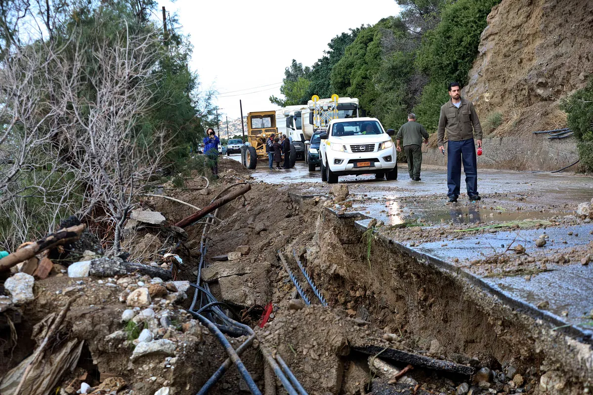
The village of Zoniana and its neighboring localities faced a critical situation as torrential waters transformed local roads into raging torrents. The sudden influx of water from the mountains caused significant damage to residential properties and disrupted the local riverbed. The sheer volume of runoff was enough to necessitate the evacuation of approximately 30 residents from their homes to ensure their safety.
Beyond the immediate physical damage to buildings, the storm caused a major breakdown in essential services. The villages of Zoniana, Livadia, and Krana were left without water supplies, a disruption that has affected roughly 2,500 people. Emergency response teams, including military machinery, have been deployed to the area to assist in clearing mud, rocks, and debris from the streets. The situation in Zoniana serves as a primary example of how rapid-onset flooding can paralyze both the living conditions and the infrastructure of mountain communities.
How did the disaster affect Ierapetra and the eastern coast?
The eastern part of Crete, specifically Ierapetra and its coastal settlements, faced some of the most harrowing challenges during the storm. Areas including Ferma, Agia Fotia, Achlia, Koutsouras, and Makry Gialos were inundated by massive volumes of water, mud, and debris. The scale of the flooding required large-scale intervention by the Fire Service to rescue individuals trapped by the rising waters.
Emergency responders were forced to perform multiple rescues, extracting more than 20 people from vehicles, homes, and tourist accommodations. A notable incident involved the evacuation of four British tourists—three women and one man—from Agia Fotia. They had to be removed by sea via a small vessel to reach the safety of the Makry Gialos pier. The road network in Lasithi also suffered heavily, with the Ierapetra–Sitia road experiencing complete closures at the 15th kilometer near Agia Fotia and the 22nd kilometer near Koutsouras due to landslides and road collapses.
What damage was recorded in the agricultural sectors of Lasithi?
The agricultural heartlands of the Lasithi Plateau were transformed into vast lakes, resulting in devastating losses for local producers. As the floodwaters spread across the plains, many fields were completely submerged, leading to the destruction of various crops. This widespread inundation has placed a heavy financial burden on the region's farmers, who are seeing their entire seasonal production at risk.
In addition to the loss of crops, the agricultural infrastructure has been severely compromised. Rural roads, essential for the transport of goods and farm equipment, have sustained significant damage from the moving water. In Makry Gialos, the situation was further complicated by power outages, which hampered the ability of residents and businesses to respond to the crisis. The combination of lost produce and broken logistics creates a long-term economic challenge for the Lasithi region.
How have other municipalities across Crete been affected?
The storm's reach extended well beyond the eastern and central regions, impacting various municipalities including Amari, Heraklion, and Chania. In the Amari municipality of Rethymno, the situation remains critical, particularly in Fourfouras, where massive accumulations of stones, earth, and debris have blocked the road networks. Similarly, parts of Heraklion faced disruptions, though the specific nature of the damage varied by location.
In the Minos Pediada municipality, specifically in Viannos, Malevizi, and Hersonissos, the damage was primarily concentrated on municipal and agricultural roads. Authorities also reported issues with retaining walls, bridges, and water supply networks, as well as damage to sections of the coastline. Meanwhile, in Chania, heavy seas caused damage to the coastal zones and the Venetian Harbor, while coastal erosion affected parts of Nea Chora. The mountainous regions of Sfakia and the Samaria National Park also faced challenges due to the high volume of water descending from the peaks.
The recovery and compensation process
As the waters recede, the focus for local authorities is shifting from immediate rescue to damage assessment. In Mylopotamos and the Heraklion municipality, officials are working to create detailed maps of the destruction. These records are essential for triggering the formal processes required to secure emergency funding and compensation for affected citizens and businesses.
Frequently asked questions
How many people were affected by the water shortages in Zoniana?
Approximately 2,500 people lost access to water supplies. The flooding caused significant damage to the water distribution networks in the villages of Zoniana, Livadia, and Krana, requiring extensive repairs by technical teams and emergency services to restore service to the local population.
What happened to the tourists in Agia Fotia?
Four British tourists—three women and one man—were evacuated by sea from Agia Fotia. Due to the dangerous flooding and rising waters, they were transported via a small vessel to the safety of the Makry Gialos pier by emergency responders.
Which roads in Lasithi are currently closed?
The Ierapetra–Sitia road has suffered major damage, resulting in complete traffic closures at the 15th kilometer (near Agia Fotia) and the 22nd kilometer (near Koutsouras). These closures are due to landslides and significant road collapses caused by the intense rainfall.
What was the peak rainfall intensity recorded?
The highest rainfall intensity was recorded in Anogeia, where levels reached 92.20 mm/hr. This extreme rate of precipitation was a primary driver of the flash floods and landslides that characterized the weather event across the island's mountainous regions.
How did the storm impact the agricultural sector?
The storm caused massive flooding in the Lasithi Plateau, turning fields into lakes and submerging crops. This has resulted in significant losses for farmers, alongside heavy damage to rural road networks and local agricultural infrastructure throughout the region.
Key takeaways
- Peak rainfall reached 92.20 mm/hr in Anogeia, triggering extreme flash flooding.
- Approximately 2,500 residents in Zoniana, Livadia, and Krana lost water access.
- Over 20 people were rescued from vehicles and buildings in the Ierapetra area.
- The Lasithi Plateau suffered extensive agricultural damage due to widespread crop submersion.
- Major road closures occurred on the Ierapetra–Sitia route due to landslides.
The path toward recovery in Crete
The immediate danger posed by the Crete weather catastrophe is beginning to subside as water levels recede, but the long-term consequences are only just becoming clear. The transition from emergency rescue operations to systematic damage assessment is a critical phase for the island. Local municipalities are now focused on documenting the destruction of homes, infrastructure, and agricultural lands to facilitate the pursuit of emergency state funding. While the physical debris is being cleared, the economic impact on farmers and the logistical challenge of rebuilding damaged road networks will require sustained administrative and financial support in the coming months.