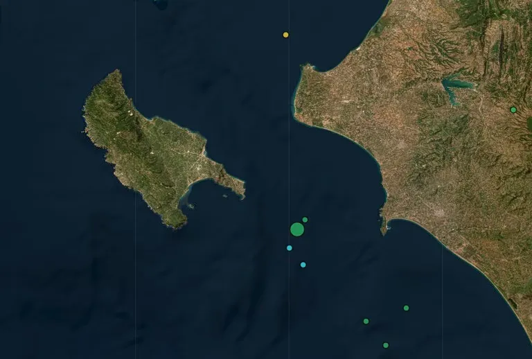
Technical specifications of the seismic event
The seismic activity was recorded in the early morning hours of Sunday, October 25, 2026. According to the automatic solution provided by the Geodynamics Institute of the National Observatory of Athens, the magnitude of the earthquake was measured at 4.4 to 4.5 on the Richter scale. Such measurements are critical for determining the potential impact on local infrastructure and coastal stability in the Ionian region.
The depth of the tremor played a significant role in how the energy was distributed. Reports indicate that the earthquake occurred at a focal depth of approximately 20 to 21 kilometers. A moderate depth like this often allows seismic waves to travel effectively across both maritime and terrestrial environments, explaining why the shaking was not confined solely to the immediate vicinity of the epicenter.
Epicenter and geographical location
The epicenter of the earthquake was located in a maritime area situated southeast of Zakynthos. Specifically, the National Observatory of Athens identified the point of origin roughly 21 kilometers to the east-southeast of the island. This positioning places the event within the tectonically active zones of the Ionian Sea, a region known for frequent seismic movements due to complex plate interactions.
Because the epicenter was offshore, the immediate physical impact on land-based structures in Zakynthos was mitigated by the distance. However, the maritime location remains a focal point for seismologists monitoring the Hellenic Arc, which is one of the most seismically active areas in Europe. The stability of the seabed in this sector is a constant subject of geological study.
Impacted regions and felt reports
While the epicenter was located in the sea, the earthquake was felt by residents in several mainland Greek prefectures. According to the reports, the tremor was clearly perceptible in the regions of Elis (Ilia) and Achaea. These areas, located on the Peloponnese peninsula, experienced the shaking despite being a significant distance from the Zakynthos maritime epicenter.
The perception of the earthquake in these mainland areas suggests that the seismic waves moved efficiently through the crust. In coastal and inland communities of Elis and Achaea, the tremor was noted during the early morning hours, around 07:15 local time. No immediate reports of significant damage or casualties were provided in the initial seismic update, though such information typically follows as local authorities conduct field assessments.
FAQ
What was the magnitude of the Zakynthos earthquake?
The earthquake measured between 4.4 and 4.5 on the Richter scale. This magnitude is classified as a moderate earthquake, capable of being felt by people and causing minor vibrations in buildings, though it is generally below the threshold for widespread structural destruction in modern construction zones.
Where was the epicenter located?
The epicenter was located in the sea, approximately 21 kilometers east-southeast of the island of Zakynthos. This maritime location means the primary energy release occurred underwater, which influences how the seismic waves propagate toward the Greek mainland and the Ionian islands.
Which areas felt the shaking?
The tremor was felt in several parts of mainland Greece, specifically in the prefectures of Elis and Achaea. Residents in these regions reported feeling the movement during the early morning hours, shortly after 07:15, as the seismic waves reached the Peloponnese coast.
Conclusion
The earthquake southeast of Zakynthos serves as a reminder of the ongoing seismic activity inherent to the Ionian Sea region. With a magnitude of 4.5 and a focal depth of 20 kilometers, the event was significant enough to be felt across the Peloponnese in Elis and Achaea, yet it remained centered in a maritime zone. While the automatic data from the National Observatory of Athens provides immediate clarity on the magnitude and epicenter, continued monitoring is essential to assess any secondary effects on the region's geological stability. For now, the event highlights the importance of real-time seismological tracking in Greece.