What is the current status of Hurricane Nolo near Hawaii?
Hurricane Nolo is currently positioned south of the Hawaiian Islands and is showing signs of rapid intensification. As of late September 2026, the storm is generating winds of approximately 150 km/h and is expected to develop into a major hurricane in the coming hours. While the center of the storm is projected to move westward, passing south of the archipelago, the threat to the islands remains significant due to the storm's expanding outer bands.
Meteorologists warn that even without a direct landfall, the peripheral zones of Nolo could trigger life-threatening conditions. These include intense rainfall, potential landslides, and dangerous storm surges. On the Big Island, rainfall totals are expected to reach as high as 51 centimeters, which poses a severe risk of flash flooding and soil instability. The storm's current trajectory suggests it will continue its path westward, staying south of the archipelago, yet the sheer scale of the system remains a primary concern for local authorities. Experts suggest the window for intensification could see Nolo reach mid-range Category 4 strength, a development that would significantly increase the danger posed by its outer reaches even as it moves away from the islands.
Impact on Infrastructure and Emergency Response
The threat from Nolo is compounded by the fact that many Hawaiian communities are still in the process of recovering from the devastation caused by Hurricane Lala in August. That previous storm resulted in approximately 100 homes being swept off their foundations, leaving many areas vulnerable to subsequent extreme weather events. Current rainfall has already begun to impact the transportation network, with several key sections of highways closed due to rising floodwaters.
In response to the escalating threat, a significant emergency mobilization is underway. More than 120 members of the National Guard have been deployed to the Big Island. Across the entire state of Hawaii, approximately 400 personnel are currently on standby, prepared to respond to emergencies as the storm's influence grows. Additionally, U.S. President Donald Trump has approved an emergency declaration, enabling the Federal Emergency Management Agency (FEMA) to coordinate support operations and release necessary emergency funding to assist the islands. This federal intervention is intended to provide the financial and logistical backbone required to manage both the immediate impact of Nolo and the ongoing recovery needs of the state.
How is Hurricane Polo affecting Mexico and Baja California?
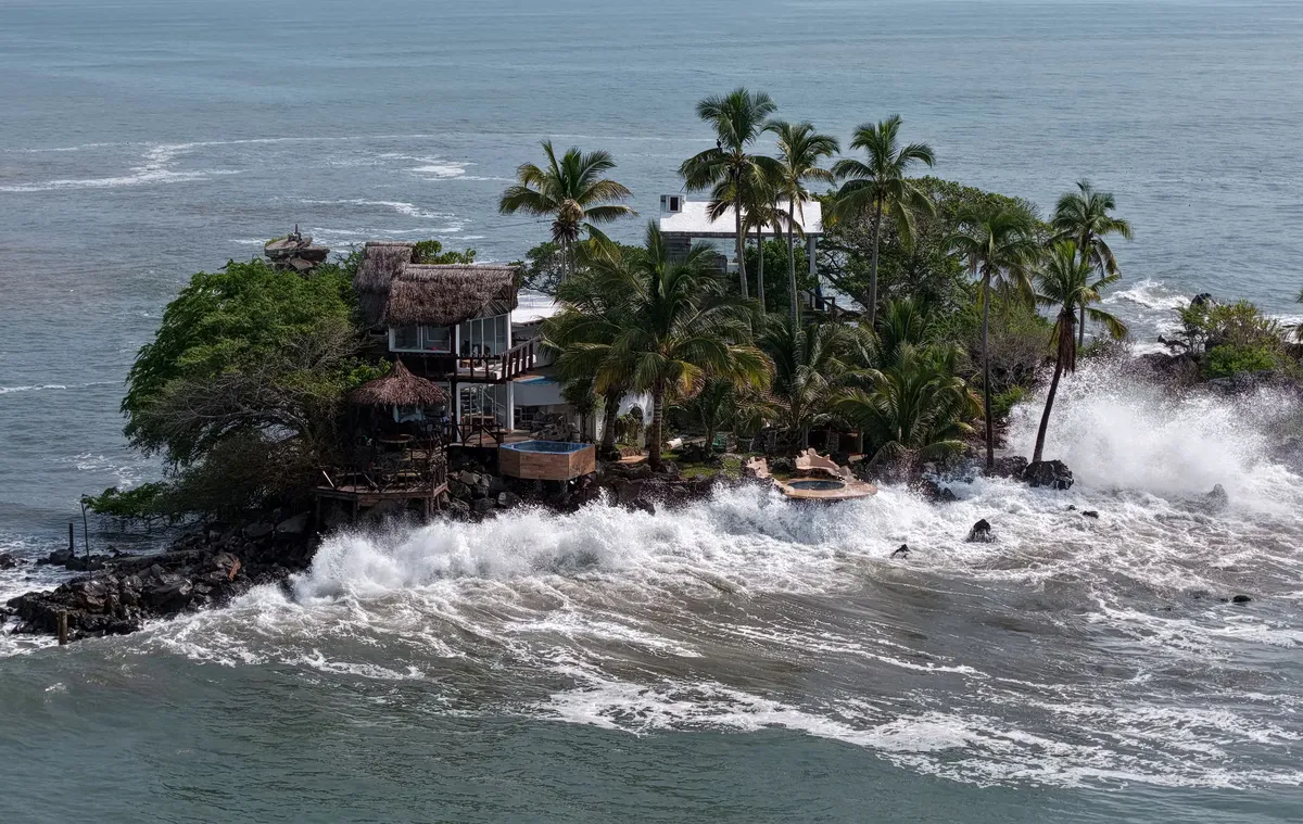
Hurricane Polo, a powerful Category 4 storm, is currently threatening the Baja California peninsula in Mexico. The system is bringing extreme weather to the country's southwestern coasts, characterized by winds reaching 220 km/h. Although meteorologists suggest the storm might weaken slightly before making landfall on Monday, the sheer intensity of the system continues to pose a major risk to coastal stability and human safety.
The primary concerns for the Mexican authorities involve widespread flooding and significant disruptions to essential services. Local communities are bracing for potential power outages and severe transportation challenges. There is a particular fear that heavy rainfall could render roads impassable, effectively isolating several remote areas from emergency medical services and supply chains. The threat to the peninsula is acute, as the storm's strength could lead to large-scale infrastructure failures in coastal regions. As the storm approaches, the focus remains on whether the projected weakening will be sufficient to prevent catastrophic damage upon landfall.
Vulnerability of San Juanico and coastal communities
The small fishing community of San Juanico is among the most at-risk locations, as it lies directly within the projected path of the cyclone. The community faces unique challenges due to its recent development and existing infrastructure limitations. Having only secured reliable electricity in recent years, the residents are highly susceptible to prolonged outages that could compromise food refrigeration and access to potable water. As local resident and hotel director Glorieli Robles Meza noted, the level of anxiety is high, as the community has not faced such a concerning situation in many years.
Logistical difficulties are also a major concern for San Juanico. Fuel supplies are currently limited, with the nearest service station located a significant distance away, forcing residents to rely on local storage tanks. In anticipation of the storm, the local municipal school is being prepared to serve as an emergency shelter. Residents are largely relying on their own personal preparations to weather the impact of the cyclone, fearing that the combination of flooding and road closures could cut them off from all outside assistance. This isolation remains the community's most pressing fear, as specialized medical services and emergency aid may be unable to reach them if the roads become impassable.
What other weather-related emergencies are occurring in the region?
Beyond the two primary hurricanes, other localized weather emergencies are complicating the regional response. On the island of Maui, a separate wildfire in a brush area has necessitated mandatory evacuations and the closure of several road networks. The situation in Maui is particularly precarious because the anticipated strengthening winds from the nearby tropical systems could exacerbate fire conditions and hinder firefighting efforts. The intersection of fire risk and tropical storm-force winds creates a volatile environment for residents and first responders alike.
The combination of multiple weather threats—hurricanes, wildfires, and heavy rainfall—creates a complex environment for emergency management agencies. The simultaneous nature of these events requires the strategic allocation of resources across vast geographical distances, from the Hawaiian archipelago to the Mexican coastline. The overlapping nature of these disasters means that resources intended for hurricane relief may be diverted to combat wildfires or manage flood-related evacuations, potentially stretching response capacities to their limits.
Frequently asked questions
Will Hurricane Nolo make direct landfall in Hawaii?
Current forecasts indicate that Hurricane Nolo is expected to move west, passing south of the Hawaiian Islands rather than making a direct hit. However, the storm's outer bands are expected to bring significant rain, high waves, and gusty winds to the islands, particularly the Big Island.
What is the severity of Hurricane Polo?
Hurricane Polo is currently classified as a Category 4 hurricane. It is producing winds of up to 220 km/h and is moving toward the Baja California peninsula in Mexico, threatening the region with extreme wind and heavy rainfall.
How is the US government responding to the situation in Hawaii?
President Donald Trump has approved an emergency declaration for Hawaii. This allows FEMA to coordinate support operations and provide emergency funding to manage the impacts of Hurricane Nolo and the ongoing recovery from previous storms.
What are the main risks for the community of San Juanico?
San Juanico faces risks of flooding, isolation due to impassable roads, and prolonged power outages. These issues are critical because the community has limited access to fuel and relies on recent electrical infrastructure that is vulnerable to storm damage.
How much rain is expected on the Big Island?
Meteorological projections suggest the Big Island could experience total rainfall amounts of up to 51 centimeters. This volume of water is expected to cause significant flooding and potential landslides throughout the region.
Key takeaways
- Hurricane Nolo is expected to intensify into a major hurricane near Hawaii.
- Hurricane Polo is a Category 4 storm threatening Mexico's Baja California.
- FEMA has been authorized to provide emergency funding for Hawaii.
- Heavy rainfall in Hawaii could reach 51 centimeters on the Big Island.
- San Juanico in Mexico faces high risks of isolation and utility failure.
Conclusion
The simultaneous intensification of Hurricane Nolo and Hurricane Polo represents a significant meteorological challenge for the Pacific region. While Nolo's path suggests it may avoid a direct hit on Hawaii, its potential for major hurricane status and extreme rainfall necessitates a high state of alert. Concurrently, the Category 4 strength of Hurricane Polo poses a direct and severe threat to the Baja California peninsula and vulnerable communities like San Juanico. As emergency services and federal agencies coordinate their responses, the focus remains on mitigating the impacts of flooding, infrastructure damage, and potential isolation of coastal populations.