Understanding 'Sea Smoke': A Natural Atmospheric Event
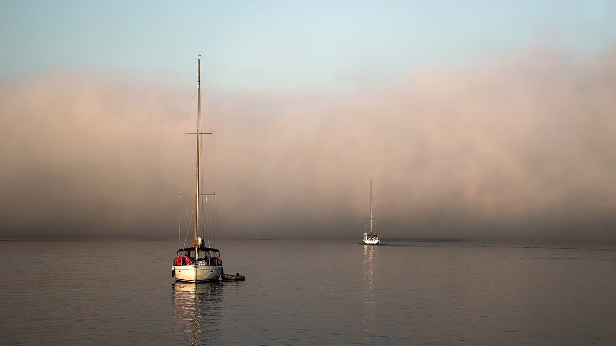
The Cycladic islands, renowned for their sun-drenched landscapes and azure waters, recently presented a different, more ethereal visage. A thick blanket of fog enveloped the archipelago, captivating residents and visitors alike. This atmospheric occurrence, often referred to as 'sea smoke' or 'steam fog,' is a fascinating meteorological phenomenon that, despite its evocative name, bears no relation to actual smoke. Instead, it is a product of specific environmental conditions, primarily the interaction between contrasting air and water temperatures.
While the sight of a misty sea might seem unusual, especially in a region typically associated with clear skies, 'sea smoke' is a natural and well-understood atmospheric process. It is essentially a form of advection fog, but with a unique characteristic: it forms directly over bodies of water rather than over land. The underlying mechanism involves the rapid evaporation of water from a warmer surface into significantly colder air, leading to saturation and condensation.
The Science Behind the Mist: Temperature Differentials and Condensation
The genesis of 'sea smoke' hinges on a distinct temperature differential. For this phenomenon to occur, a mass of exceptionally cold air must move over a body of water that is considerably warmer. When this happens, the warmer water surface begins to evaporate at an accelerated rate. The water vapor rises into the frigid air directly above it. Because the air is much colder, it has a lower capacity to hold moisture. Consequently, the rising water vapor quickly cools to its dew point, leading to rapid condensation. This condensation manifests as tiny water droplets, visible as a swirling, smoke-like mist hovering just above the water's surface.
Think of it similarly to seeing your breath on a cold day. Your warm, moist breath comes into contact with the cold ambient air, and the water vapor in your breath condenses into visible droplets. 'Sea smoke' operates on a grander scale, with the entire surface of a warm sea acting as the source of moisture. The greater the temperature difference between the warm water and the cold air, the more pronounced and dense the 'sea smoke' will be.
Factors Influencing 'Sea Smoke' Formation
- Temperature Gradient: The most crucial factor is a substantial difference in temperature between the sea surface and the overlying air. Typically, the air temperature needs to be at least 10-15 degrees Celsius (18-27 degrees Fahrenheit) colder than the water temperature for significant 'sea smoke' to form.
- Moisture Content: While the air itself is cold, it must also be relatively dry initially. This allows it to absorb a significant amount of moisture from the warmer water before reaching saturation. If the cold air is already humid, the condensation will be less dramatic or may not occur as 'sea smoke.'
- Wind Conditions: Light breezes are conducive to the formation of 'sea smoke'. They help mix the air layers, distributing the evaporated moisture and allowing for more widespread condensation. Strong winds, however, tend to disperse the fog too quickly, preventing its accumulation.
- Water Body Characteristics: Larger bodies of water with consistent warmth are more likely to produce 'sea smoke' when cold air masses pass over them. Coastal areas, particularly those with deep, relatively warm waters, are prime locations.
Distinguishing 'Sea Smoke' from Other Fog Types
It is important to differentiate 'sea smoke' from other common types of fog, as their formation mechanisms vary significantly:
- Radiation Fog: This type of fog forms over land, usually on clear, calm nights when the ground cools rapidly by radiating heat. The air above the ground then cools to its dew point, leading to condensation. Unlike 'sea smoke,' radiation fog is not directly linked to a warm water surface.
- Advection Fog: While 'sea smoke' is a form of advection fog, advection fog generally refers to fog that forms when warm, moist air moves horizontally over a cooler surface (either land or water). The cooling of the warm air by the cooler surface leads to condensation. The key distinction for 'sea smoke' is the movement of cold air over warm water, reversing the typical advection fog scenario.
- Upslope Fog: This occurs when moist air is forced to rise up the side of a mountain or hill. As the air ascends, it cools adiabatically, reaching saturation and forming fog. This is a terrain-dependent phenomenon, unlike 'sea smoke.'
Historical and Global Occurrences
'Sea smoke' is not exclusive to the Cyclades or even the Mediterranean. It is a globally observed phenomenon that can occur in various cold-water regions when the right atmospheric conditions align. It is particularly common in polar and subpolar regions, such as the Arctic and Antarctic, where frigid air frequently moves over relatively warmer open water. Sailors and coastal communities in these areas are often familiar with this misty display. It can also be observed in temperate zones during winter months, especially over large lakes or coastal waters following a sudden drop in air temperature.
Historically, 'sea smoke' has sometimes been associated with folklore or mistaken for actual fires at sea due to its visual resemblance to plumes of smoke. However, scientific understanding has long since clarified its meteorological origins, dispelling such misinterpretations. Its appearance often signifies a significant shift in weather patterns, specifically the arrival of a cold air mass.
The Cyclades Event: A Local Perspective
For the Cycladic islands, the recent occurrence of 'sea smoke' highlights the dynamic nature of regional weather. While the Mediterranean climate is generally mild, seasonal variations can bring about these striking atmospheric events. The specific conditions that led to the 'sea smoke' over the Cyclades likely involved an influx of unusually cold air from a northerly or easterly direction, interacting with the relatively warmer waters of the Aegean Sea. The islands' geographical position, exposed to open sea, makes them susceptible to such phenomena when these contrasting air masses converge.
Such events, while beautiful, can sometimes pose challenges, particularly for maritime navigation, as visibility can be significantly reduced. However, they also offer a spectacular demonstration of atmospheric physics in action, transforming familiar landscapes into scenes of ethereal beauty. The 'sea smoke' over the Cyclades serves as a reminder of the Earth's complex and ever-changing climate system, where seemingly simple interactions of temperature and moisture can create breathtaking natural displays.
In conclusion, the 'sea smoke' that graced the Cyclades was a testament to the intricate dance between air and sea. Far from being actual smoke, it was a magnificent natural phenomenon, born from the simple yet powerful principle of temperature differentials driving evaporation and condensation. It offers a valuable opportunity to appreciate the nuanced beauty and scientific principles governing our planet's atmosphere.